

Territorial and Social Analysis

We analyse the socio-economic dynamics with extreme granularity to support equitable and sustainable policies. We study poverty, consumption, and fragility to transform data into community well-being.
Interested in the Service?

Objectives

Transforming territorial data into social impact

We study local socio-economic dynamics with scientific rigour and granularity. We integrate official sources and geographical data to mapping poverty, consumption and needs, providing a clear compass for public policy and responsible investment.

Wellbeing and Frailty Indicators

We map the territorial vulnerabilities and income levels to identify areas in need of priority intervention and social support.

We analyse spending behaviour and the distribution of services on the territory to optimise the presence of commercial activities and public services.

Mobility and Infrastructure

Let's assess territorial accessibility and movement flows. to support the planning of more efficient and sustainable transport.

Methodology

Our Method Explained in 3 Steps

We integrate official databases and web streams to map the territory with surgical precision. Through econometric models and synthetic indicators, we transform complex phenomena into clear maps and scenarios, offering a granular vision indispensable for equitable policies and sustainable strategies.

Multilevel Sources
We cross-reference official data from sample surveys (such as HBS and AVQ) with administrative databases and open data. This integration ensures a solid statistical basis and a comprehensive coverage of the territory.
Key Features:
Granular and Modelling Analysis
We go beyond aggregate data to study phenomena at the local, municipal or neighbourhood level. We use econometric models to isolate key variables and understand the real determinants of social dynamics.
Key Features:
Synthesis and Decision Support
We transform complexity into synthetic indicators of well-being and sustainability, visualised through interactive maps. We develop scenario simulations that concretely guide governance and strategic planning.
Key Features:

Application Example: Granular Indicators (Small Area and Spatial Analysis)

Geostatistical Models for the Granular Analysis of Municipal Consumption

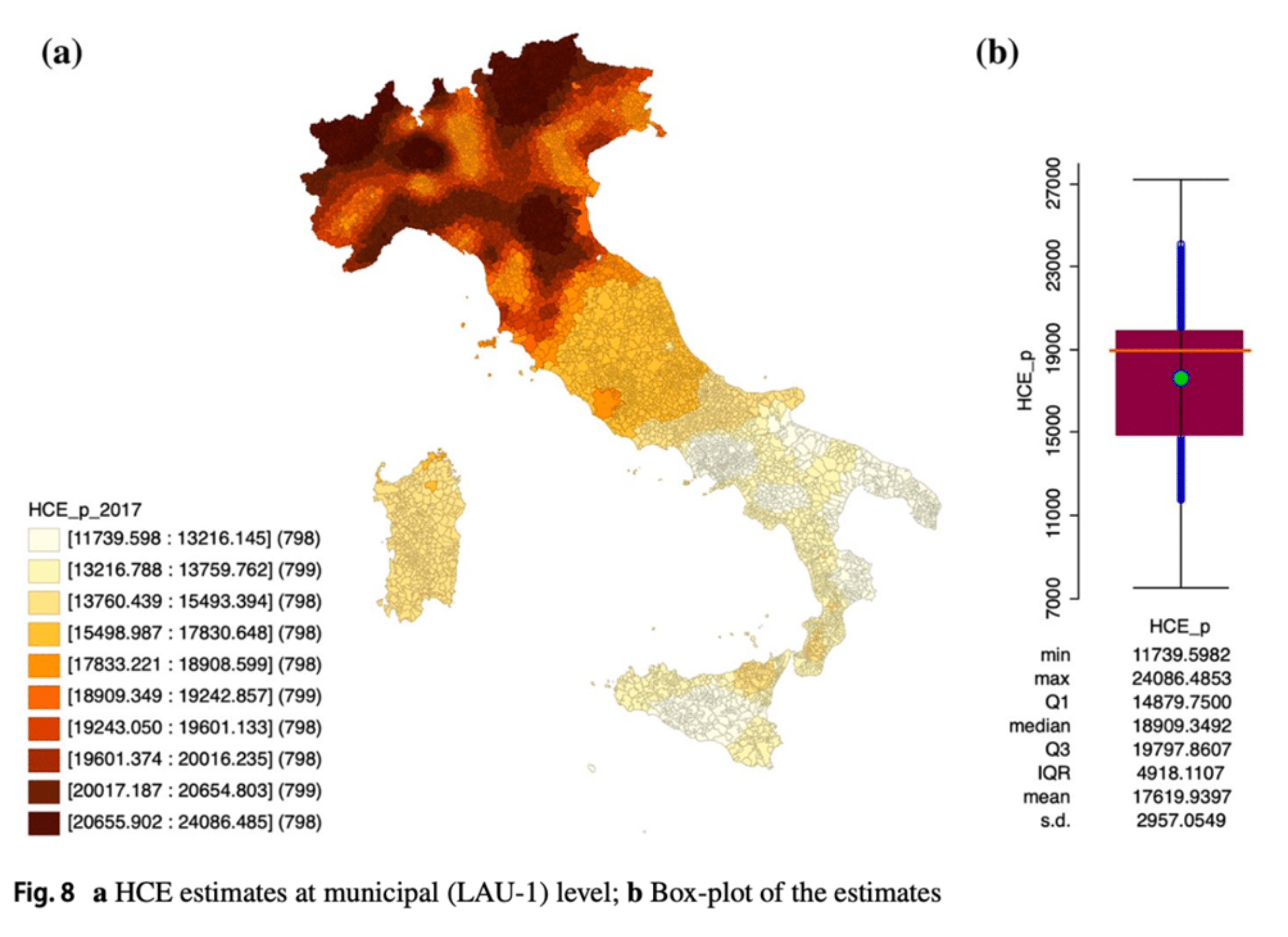
The analysis focuses on determining the Household consumption expenditure with high territorial detail.

Thanks to the use of advanced spatial statistical methodologies, such as the co-kriging and the Regression kriging, it is possible to obtain accurate estimates at the municipal level. These interpolation models allow for the mapping of local economic dynamics, overcoming the limitations of traditional surveys.

The approach transforms partial data into comprehensive maps of material well-being, This offers a strategic tool for the planning and monitoring of regional economies. The precision of geostatistics thus guarantees a granular and scientifically sound view of consumption behaviours on a local scale.

Case Studies

The impact of our analyses: case studies and applications

We translate scientific rigour into concrete solutions through targeted projects ranging from market monitoring at urban planning. Let's discover how our granular analyses and complex data integration have generated strategic value for institutions and businesses.